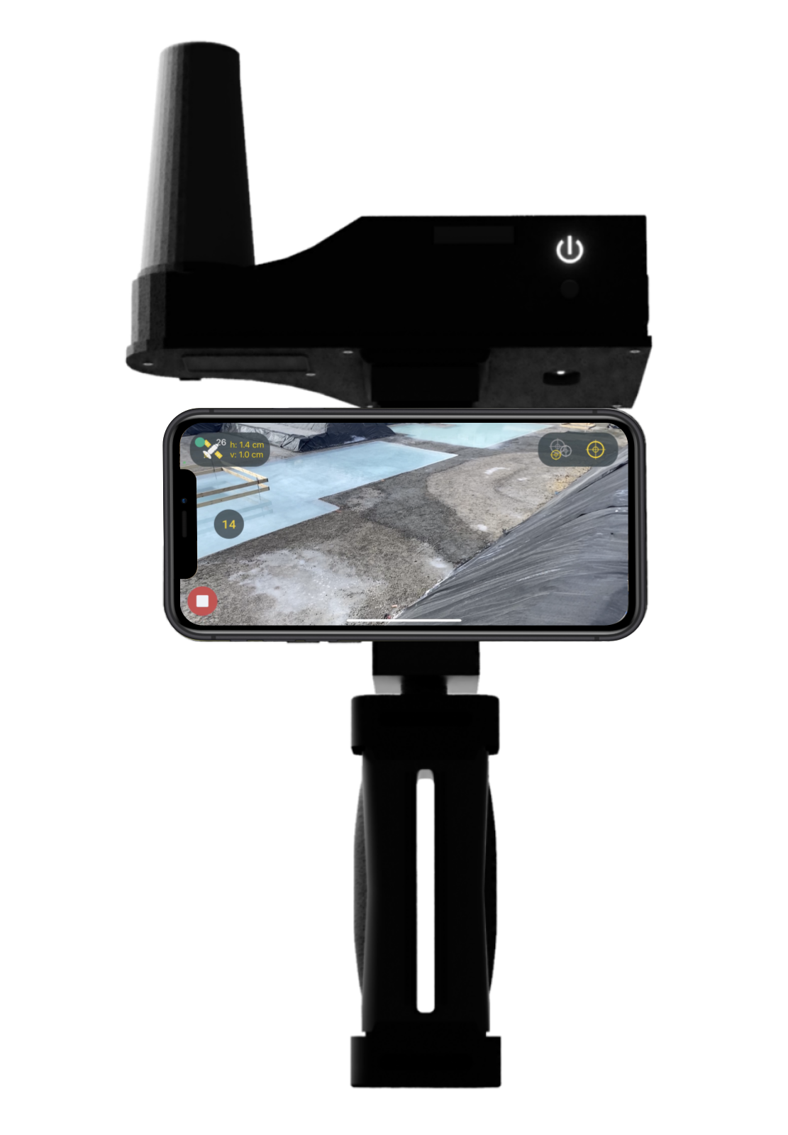
HaX RTK 2.0, the new GNSS rover
Specifically designed for the KickTheMap 3D mapping app, it allows you to georeference all your surveys.
Technology
Best-in-class triple-band GNSS RTK receiver.
iOS/Android
More than 300 devices compatible.
Battery
15 hours of operation.
Innovation
3D mapping and points capture from a distance.
Accuracy
Centimeter-level positioning for a better 3D reconstruction.
Affordable
Trusted by Industry Leaders


A unique web platform for your projects
Pricing
Most Popular
Free
Trial
- 150Pictures/job
- Up to 5jobs
- No support
- -
Most Popular
Pay-per-use
€0.09/picture
- UnlimitedPictures
- UnlimitedJobs
- BasicSupport
- -
Most Popular
Starter
€89/month
- 2000Pictures overall
- UnlimitedJobs
- AdvancedSupport
- €0.09/extra picture
Most Popular
Business
€179/month
- 5000Pictures overall
- UnlimitedJobs
- AdvancedSupport
- €0.07/extra picture
Where to Buy
Switzerland
KickTheMap
Avenue Bergières 10, C/o Impact Hub, 1004 Lausanne, Switzerland


Autria
Landmark Produktions- und Handelsgesellschaft m.b.H.
Bahnhofstraße 8b, 6922 Wolfurt, Austria
United Kingdom/Ireland
Jennings Geomatics
23 Wadham Street, Weston-Super-Mare, Somerset, England, BS23 1JZ


The Netherlands
Nemex Geo-Expertise
De Morgenstond 35, 5473 HE Heeswijk Dinther, The Netherlands


Switzerland
KickTheMap
Avenue Bergières 10, C/o Impact Hub, 1004 Lausanne, Switzerland
Try it now!
Download the mobile app and try it for free
FAQ
The mobile app allows users to capture data in their environment and upload them to the KickTheMap cloud. After processing time, the 3D model is delivered on our web platform (my.kickthemap.com) and the user is notified by email. Every user has a secured access to all its 3D models.
Delivery time mainly depends on the amount of uploaded data, but projects featuring less than 1000 pictures have a guaranteed delivery time of 24 hours.
The KickTheMap app captures only still pictures and some geospatial data in order to facilitate the 3D reconstruction. The app does not require a previous experience in photogrammetry or 3D modelling since it automatically takes pictures, based on device movement.
If your mobile device is LiDAR compatible then the KickTheMap engine will fuse both images and LiDAR data for more complete results.
No video is captured by the app, since still images are way lighter and better quality than video frames for 3D recontruction.
Accuracy highly depends on many factors such as device camera sensor, lighting, device/target distance and data quality (no fast movement, no quick rotations...). In nominal conditions, a relative error of 3 cm / 1.2 inch (Root Mean Square Error) can be expected. Contact us at info@kickthemap.com, if you want to know more about nominal conditions and accuracy.
The new GNSS RTK Rover Hax allows to directly georeference all your surveys. Get it touch with us for more info.
If you do not own the Hax, the KickTheMap app has a very unique feature to accurately capture ground control points in order to georeference 3D models. At least 3 control points are required, well spread around the area of interest. Coordinates related to control points can be uploaded on the web platform afterwards to start the 3D reconctruction.
If you do not have control points, you can still scale your model with a scale bar to ensure that a good relative accuracy is reached.
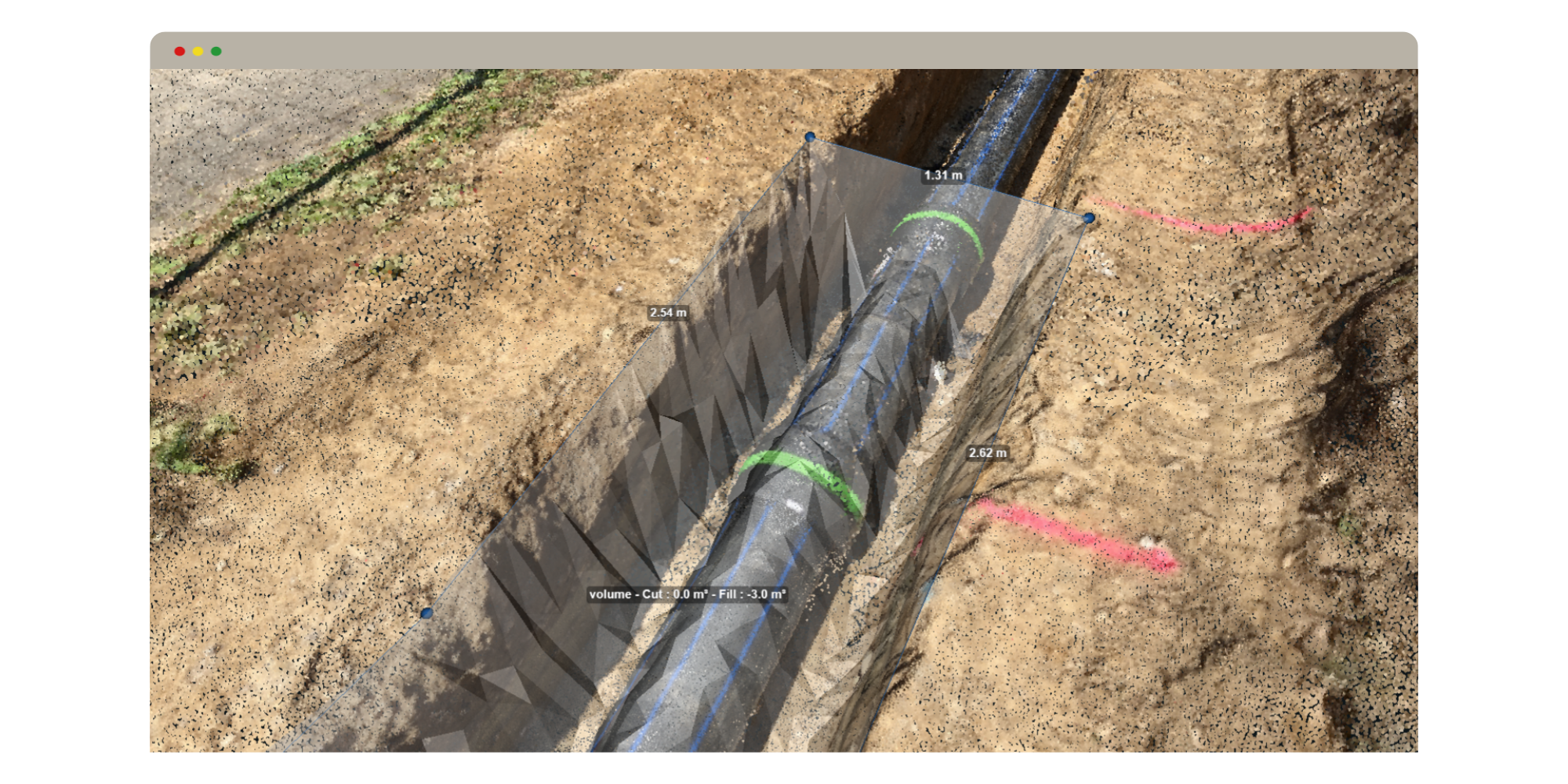
The web platform allows to visualise, measure (distances and volumes), draw features (with attributes) and export objects to third party software such as AutoCAD or GIS software.
It is definitely not mandatory to use our platform since you can also download raw point clouds in .las format and use them in your existing workflow.